
I’ve installed and been fiddling around with OsmAnd~ for a few days now. And I have to say it is dense. It has way too many details and it feels overwhelming.
For all its faults, Google Maps works really well when it comes to showing information. More and more details are shown as you zoom in.
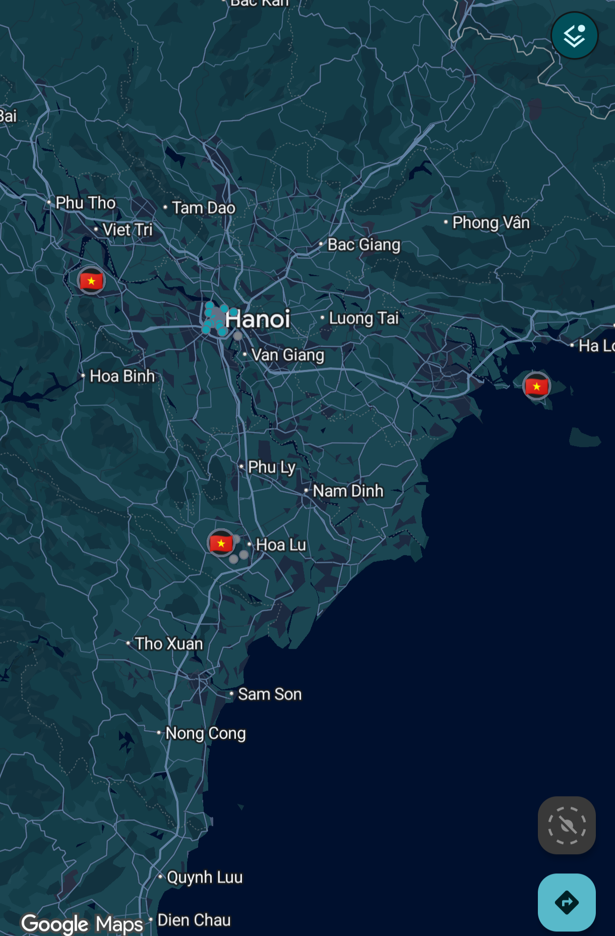
That’s not the case with OsmAnd.
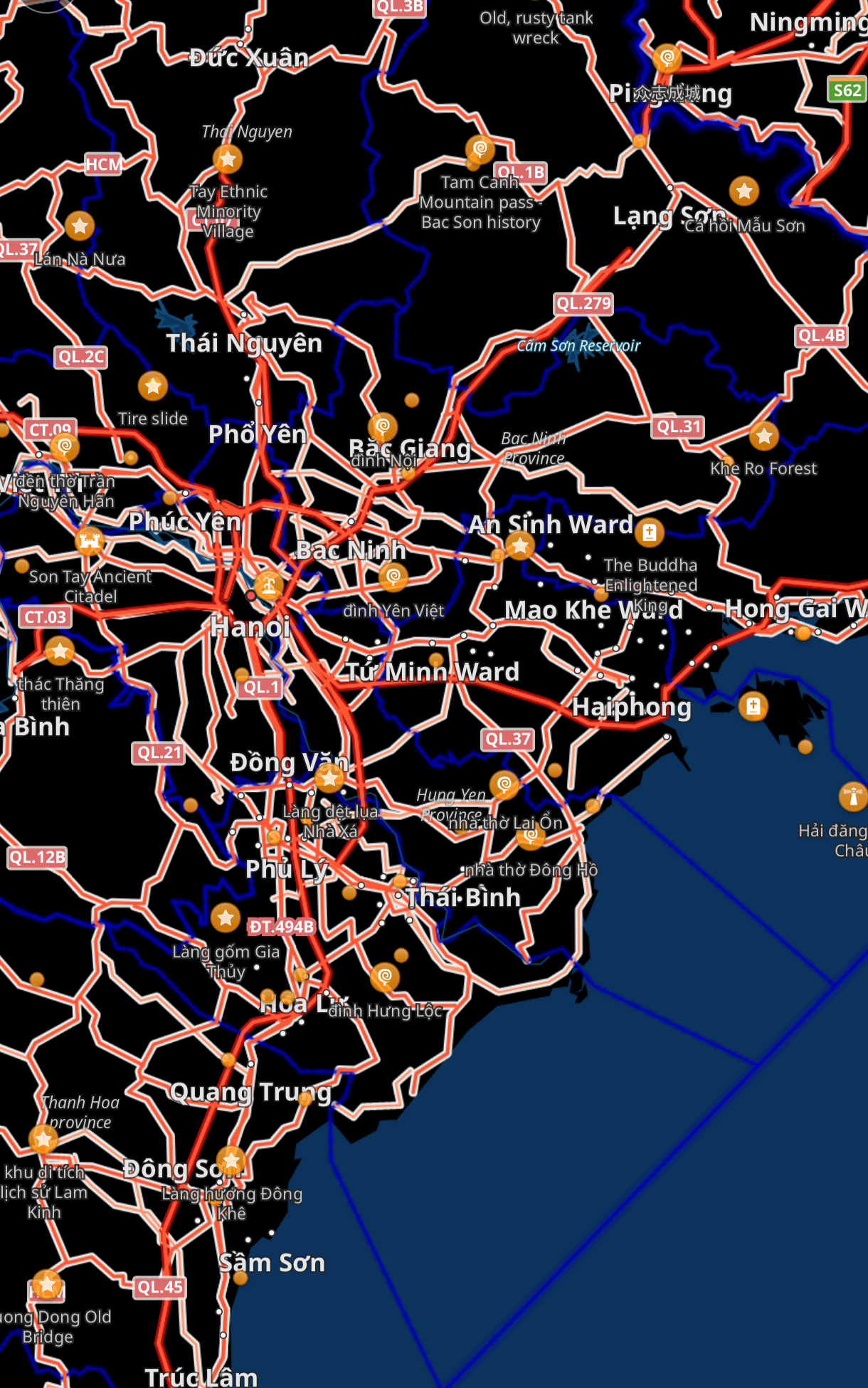
So much detail is on the screen when I’m looking to just get an idea of the region and I don’t even know where to start.
How can I make it look like Google Maps? Maybe I’ll be able to use that as a starting point and configure it further as needed?
Thanks.
CoMaps is much cleaner. Not as much functionality as Osmand, but it’s easier to use.
I love CoMaps but goddamn I don’t understand some decisions they made. Like, addresses in search are displayed as
Some City, Some Road, 123, Some State, Some Country
WTF is that.
And of the four buttons on the main screen at all times, the very first one is an About page.
I agree the addresses display strangely but the search still works, so it’s okay for me.
But I’m really commenting to say that the left of the four buttons can be changed! Settings > Interface > Left button setup. Mine is set to add a place to OSM as I like to edit, but it can also be a shortcut to settings, record a track, or be removed entirely.
Ooh, nice! Thanks!
CoMaps is really neat, and is superior to Google Maps for me because you can download offline maps, meaning you can still view it without a signal. It has a slick UI and is even available on (desktop) Linux (better mobile Linux support is being worked on)
Google Maps has had offline maps for years and years…
Oh, I didn’t know that! I do still like CoMaps more though, since it’s open-source, community-run (it’s in the name!), and generally a more pleasing UI in my opinion (it genuinely looks really nice!)
And of course you have the benefit of not having loads of trackers on your maps app (which should be designed to track your location, not your ad preferences!)
I’m also super surprised how accurate the navigation is, even for pedestrian streets it had all the things you would want: automatic path switching when you make a wrong turn, voice outputs that auto disable when your headphones disconnect, and a really accurate time left estimate!
Only for car routes. It’s bummer when I need to check route while on my bike and with zero data.
Not properly, and without walk routing
I did OSMand and CoMaps for about a year. Got so sick or having to look up addresses on search, use an online tool to convert addresses to coordinates, and then having no traffic information in the app.
Both app systems are almost there but it was too much friction even for me.
Solution? CoMaps for everyday, gmaps in private space on Grapheme for when I need to not be hassled with the above annoyances
Scrolled down many comments to find yours!
OsmAnd has built-in address lookup and Comaps (and most others I tried) does not.
I would honestly rather use Comaps than OsmAnd, but having to find the longitude and latitude of an address using a different website and then plugging that into Comaps was way too much work. (And the address wasn’t always found anyway.)
I would gladly pay for a Google Maps alternative but I recently tried Magic Earth and was unimpressed and didn’t find it worth paying for.
Don’t change the settings from defaults and it won’t look like this.
You’ve specifically changed the profile from default or adjusted settings for one of them to give extra highlight to the roads.
That, or you’ve changed the theme from default.Don’t change the settings from defaults and it won’t look like this.
It looks like that because I tried to make it look like Google Maps first, as a baseline. I can’t seem to get it just right. It’s either too sparse or too dense.
I think OSMand is just fuggly on porpouse - as somebody else said COmaps is a lot better
OSMAnd is just for a different data-driven type of user. Has a lot of different options which can make the interface very cluttered and confusing, but also offers a ton of functionality that other maps don’t.
Having a lot of functionality doesn’t necessarily mean having a bad interface - check KDE for example.
I think they simply have way too many more developers than UI designers.
That’s my biggest complaint about most open source projects. They’re very clearly made only by a developers, and not one designer.
You have a good point about the UI. Compare the screenshots and Maps has a nicer UI that shows names of the major places, major and minor roads have different widths, and gives sense of overall geographical features (lakes, hilly areas etc.)
KDE is a great example of what I was talking about. It’s exactly why I don’t use it.
Wait, you mean you don’t use kde because it isn’t cluttered by default?
Because it is
Oh, kde is is cluttered by default? What desktop do you use then? I’m really curious
GNOME ofc.
Yeah, go with CoMaps. It has less features than OsMand, but in return you get a user friendly UX/UI.
CoMaps is definitely what you want. The search isn’t the best, but the map design is better than Google’s design which even at high zoom levels refuses to show many POIs and hides most of everything. CoMaps shows all POI possible without looking cluttered
OsmAnd is more for power users, it is slow and ugly but can do anything. I use it for bike routing with the external BRouter app, and it is far better than all other bike nav, but a bit of a pain.
Neither CoMaps nor Organic maps do that. I had osmand downloaded and removed it, probably because it looked like that.
HERE WeGo, but it’s only an alternative in terms of navigation.
The main important thing that these other maps alternatives don’t do good enough for me is to have enough live-ish updates of changing conditions and status of things happening in an erea, this is only something thst I think will happen if it hits a critical mass like with Google maps and its ability to know stuff from googling.
I don’t think I’m gonna step back to what are just fancier looking paper maps on my phone just because I don’t like google. an alternative to me needs to replace Google’s situational awareness, not merely its navigation.
Is there a way to make this happen? Like to me Google maps feels like a geography based portal into Google search that happens to also do the useful thing of navigation, I’d want some way for these maps alternatives to have information in them compiled from search indexes somehow.
I know thst exists already to some extent but its been wrong often enough in my experience to not trust it so this is why I think there needs to be some sort of fancier backend system for federating networks effects from internet resources if thst makes sense. Like if there was more incentives for contributions to happen from things where this infornation is more likely to change such as in buildings and traffic intersections, guerrilla data logging anyone? Haha
Google maps didn’t have that fully integrated until they bought Waze, if I recall correctly
I relied extensively on Google Maps when I was in Japan and it worked flawlessly.
And I can’t drive so I’m saying this as someone who either walked or used public transportation to travel.
I came across a fairly new navigation map called Vela Map. It is a alternative to google maps for privacy but keeping some of the favourite things of google maps like traffic and addresses with detail information about shops etc. It does use google api as stated on the github page. Still being developed but can see a potential for this app to become a good alternative to google maps.
Do people not like Organic Maps anymore? I used that for a long while but none of the people on here seem to recommend it. I will admit, it did handle street addresses poorly to certain locations. But it was much better than OsmAnd.
Organic Maps was forked and is now CoMaps
Didn’t realize this, thanks for letting me know.
I’ve used Organic (now CoMaps) for a while now. Mostly been great. Interface is so much faster than OSMand (slow rendering) or Google maps (no networking needed).
Driving route planning doesn’t know about traffic, so it’s always optimistic about time.
Some rural towns in my country disappear unless you zoom in more, which is a pain sometimes.
Besides CoMaps, only other Google Map alternative that works close to it is Mapquest. Its not as private but it gets the job done and works suprisingly well.
If you’re in Vietnam, there is also KBlack offline navigation.
It’s a pretty young project but looks very clean from the screenshots. I’ve never used it as I’m in another part of the world.
I’m not in Vietnam, just planning a trip (still unconfirmed).
OSMand is clearly made for hiking and other sports. Pretty much a must have. I use it all the time.
Certainly not for driving though. For example it considers every trail as a road, and tell you to take a left when really right is a tiny dirt road.
They should remove the car option to avoid more confusion.